
Find the Best Running Routes in DC, Maryland, and Virginia
Finding a running route in the DMV is not the hard part. Finding the right route for the right workout, with parking, a Metro stop, and a bathroom you can actually count on, that's where things get complicated.
We built something to fix that.
The DMV Running Route Finder is a free tool that helps runners in Washington DC, Maryland, and Virginia find curated routes organized by workout type. There are 24 routes in the database, spanning the District, Northern Virginia, and the Maryland suburbs. Pick your workout category and the tool surfaces routes built for that specific effort. Tempo runners aren't getting sent to a rolling trail. People doing hill repeats aren't pointed toward Hains Point.
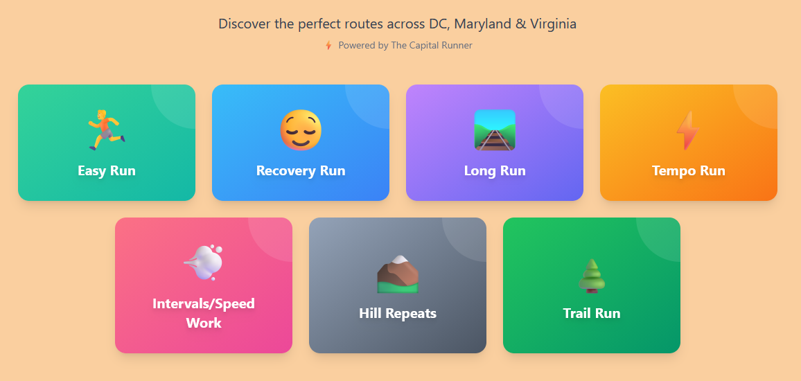
There are seven workout categories: easy run, recovery run, long run, tempo, intervals and speed work, hill repeats, and trail run. Click one and you'll see routes that fit that session.
Every route comes with the logistics you actually need before you leave the house. Nearest Metro station. Parking situation. Restroom access. Lighting conditions. Water fountain locations. Shade coverage. Whether it works for a jogging stroller. It's the kind of information that normally lives in your head after years of running here, or that you piece together from three different Reddit threads.

The DC side of the tool covers twelve routes. The National Mall Loop is a 4.5-mile circuit on gravel and pavement, with restrooms at the major monuments and water available at multiple points. Rock Creek Park handles longer efforts and trail running, with enough tree cover to make summer miles bearable. East Potomac Park at Hains Point is one of the flattest stretches in the city, which makes it useful for tempo work and speed sessions. Theodore Roosevelt Island sits just off the Rosslyn waterfront and gives you a genuine trail run without leaving the city limits. The Anacostia Riverwalk Trail runs along the eastern waterfront and connects Yards Park, Navy Yard, and Anacostia Park. Rounding out the DC options are Capitol Hill Loop, Georgetown Waterfront, Fort Circle Trail, the National Arboretum, Kenilworth Aquatic Gardens, and the Navy Yard area around Yards Park.
Seven Virginia routes are in the tool.
The Mount Vernon Trail runs 18.5 miles along the Virginia side of the Potomac, from Theodore Roosevelt Island south to George Washington's estate in Mount Vernon. It's paved, well-lit, and has new water fountains installed as part of the trail's recent renovation. The Custis Trail connects Arlington to the W&OD and adds elevation that's hard to find elsewhere in the region. The Washington and Old Dominion Trail stretches 45 miles into Loudoun County and is the go-to for Northern Virginia runners who need long run mileage without doubling back. Four Mile Run is a flat, paved path through Arlington that works well for tempo efforts. Great Falls Park in McLean puts you on rugged terrain above the Potomac gorge. The Burke Lake Loop in Fairfax County is a 4.7-mile wooded circuit around the reservoir, good for easy and recovery runs. The Potomac Heritage Trail rounds out the Virginia options with a more technical, rooted surface along the river.
Five Maryland routes round out the tool.
The C&O Canal Towpath runs 184.5 miles from Georgetown to Cumberland, but most DC-area runners use the stretch between Georgetown and Great Falls, about 14 miles of flat, crushed stone. The Capital Crescent Trail connects Georgetown to Silver Spring on a smooth, paved surface and is one of the most popular running corridors in the region. Sligo Creek Trail in Montgomery County is a quieter option, 10.2 miles of paved trail through a wooded stream valley that sees far less traffic than most regional paths. Greenbelt Park in Prince George's County has dirt paths through a forest that draws a fraction of the crowds you'll find on the Capital Crescent. Lake Artemesia in College Park is a 1.35-mile paved loop around a man-made lake, best used as a warmup, cooldown, or an add-on to a longer run via the Anacostia Tributary Trail System.
Most route finders sort by distance or location. This one sorts by how you're training. That distinction matters more than it sounds. A five-mile run on the Capital Crescent Trail is a different experience depending on whether you're supposed to be jogging easy or pushing at threshold. Matching the route to the workout, rather than just the mileage, is how the tool was designed.
The logistics data is the other piece. Knowing that a route has Metro access, where the nearest parking is, and whether there's a restroom at the midpoint are the details that determine whether a run actually happens. That information is here for all 24 routes.
The DMV Running Route Finder is free and works on your phone.